The list goes on..... Second part :
13. Nandi Hills
Type :Hill, Fort , Temples, Mosque
Nearest Town: Devanahalli
Nearest Town: Devanahalli
Distance from Bangalore: 45kms
Trek Distance: About 2 km (one way)
Trek level: Easy
Directions: Take the Hyderabad highway NH7 till Devanahalli. Then take a left turn ,travel for about 22kms to reach the peak
About: This is the highest peak around Bangalore . It is about 1400mt above MSL . This is the most commonly visited places around Bangalore. The fort was built by Doddaballapur Nadaprabhus and later improved by Tippu Sultan. This place is an excellent place for bird watching. People who don't wish to trek, can take their vehicles up to the peak.
14. Melukote  |
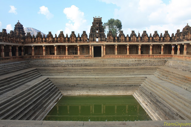
| A Water Pond at Base of Nandi Hills |
 |
| Mantapa on the Way to Nandi Hill Peak |
Type :Hill, Temples, Wildlife
Nearest Town: Nagamangala
Distance from Bangalore: 160kms
Directions : There are two ways A) Take the Mysore road , cross Mandya and then take a right turn and follow directions to reach Melukote. B)Take the NH 48 Mangalore highway till Belluru cross , then take a left turn, proceed a little further to reach a Y fork. Take a right turn here and follow directions to reach Melukote.
About: This place is also known as 'Thirunarayanapuram'. It is built on rocky hills known as Yadavagiri or Yadugiri overlooking the Cauvery valley. Approach roads to this place are very picturesque. It is a temple town with many temples, main ones being Cheluvanarayana Swamy Temple and Yoga Narasimha Temple .There are many Kalyanis here .There is also a secret cave underneath the Yoga Narasimha temple . It is believed that the great Srivaishnava saint Sri Ramanujacharya did penance for 14 years here . But the entry to the cave is prohibited now. Other attractions are the wildlife sanctuary and the museum. If one is fond of Puliyogare , then this is the place to taste it the best. Excellent Puliyogare is served here at all hotel and eateries. Overall, a great place for family outing .
 |
| Yoganarasimha Swamy Temple, Melukote |
 |
| Incomplete Rajagopura, Melukote |
Type :Hill, Fort , Temple
Nearest Town: Gudibande
Distance from Bangalore: 75kms
Trek Distance: About 3kms (one way)
Trek level: Easy
Direction : Take the Hyderabad highway NH7 till Chikballapur.Continue until you reach Perasandra. Take a left turn to reach the Gudibande.
About: Gudibande fort was built by a local chieftain named Byre Gowda. With more than 13 (locals say there are 19) rock ponds at different levels, this fort seemed to have a perfect rainwater harvesting system.There is a temple on the peak dedicated to Lord Shiva , which has been renovated recently with marble flooring. The Shiva linga in the temple is believed to be one amongst the 108 jyothirlingas in India. When viewed from here, the Byrasagara lake looks like the map of India.
 |
| Gudibande Fort |
 |
| Ruins of Temple inside Gudibande Fort |
Type :Hill, Temple
Nearest Town: Kolar
Distance from Bangalore:40 km
Trek Distance: About 3kms (one way)
Trek level: Moderately Difficult.
Direction: Via NH4 Kolar road, travel till you reach Kamat Upachar , from here take a right turn adjacent to Volvo godown. Travel a little further till you reach a small hamlet . Then take a left turn to reach the base of the hill .
About: This hill is a paradise for rock climbers. Steps are laid up to the cave temple which is dedicated to Lord Hanuman . Here on, one can go up till the peak, but there is no definite way or directions. One can use the line of electrical poles for guidance. There are a lot of caves along th e way to the hill top. The view from the top is awesome .
 | |
| View from the Top |
Type :Hill, Water, Temple
Nearest Town: Kolar
Distance from Bangalore:60 km
Trek Distance: About 6kms (one way)
Trek level: Easy.
Direction: Via Kolar road till you reach Kolar. From the bus stand, take a right turn , this road will lead to Antaragange.
About: Antaragange is a mountain situated in the Shathashrunga mountain range in Kolar . Antaragange literally means "Ganges (Holy water) from deep" in Kannada. Antaragange is famous for the temple situated on the mountain. In the temple is a pond which gets a continuous flow of underground water from the mouth of a Basava (stone bull). There is a steep, narrow path to the top of the mountain. The mountain contains volcanic rocks and lot of caves around.
 |
| Antaragange Spring |
 |
| Rajagopuram, Theruhalli |
Type :Dam, Water
Nearest Town: Magadi
Distance from Bangalore:30 kms
Direction: Via Magadi road till you reach T G Halli
About: T G
Halli Dam or the Thippagondanahalli Reservoir, also known
as Chamarajsagar is located
at the confluence of the rivers of Arkavathi and Kumudavathi. It serves as a
major source of drinking water for Bangalore west. The dam was built under the supervision
of Sir M Visvesvaraya. Entry into the dam premises requires prior permission
from concerned authorities, although there are many ways one can enjoy the dam surroundings.
This place is a heaven for bird watchers. Read more
More places from Bangalore : Read
Related Posts:
1. 101 places to visit around Bangalore within 125 km
2. The Mighty Madhugiri Fort
3. Waterfalls near Bangalore
More places from Bangalore : Read
Related Posts:
1. 101 places to visit around Bangalore within 125 km
2. The Mighty Madhugiri Fort
3. Waterfalls near Bangalore


Thanks for sharing, will come in handy when planning for the next outing.
ReplyDeleteWonderful list of places. Good compilation.
ReplyDeleteAny more info on Melukote wildlife sanctuary?
ReplyDelete