Type: Hill, Fort, Mosque, Temples
Distance from Bangalore: 120 km
Trek Distance: 2 km (One Way)
Trek level: Easy
Directions from Bangalore: Bangalore – NH4 –
Dabspet – Right Turn – Madhugiri – Bypass - Midigeshi
About: The fort of Midigeshi is believed to have been built by a
local Chieftain named Nagareddi, who named the fort after his
wife Midigeshi, called so because she had hair (kesha) long enough that
reached her heel (midi). This place was ruled by queens of the same family for
a long time.
Read more……
 |
| Fort Midigeshi |
Type: Ancient Capital, Temples
Distance from Bangalore: 50 km
Directions from Bangalore: Bangalore – NH 4 –
Dabspet – Right Turn Towards NH 207 –
Drive Till Railway Crossing – Left Turn – Manne
About: 'Manne' is the erstwhile capital city of the Gangas, who shifted their capital from Avani of Mulbagal Taluk to here, and later to
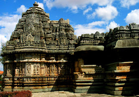
Talakad. There are many temples present here which were built during the reign of the Gangas. While most of them are completely renovated, a few such as the Kapileshwara temple (though in ruins now), proves a great witness to the excellent style of Ganga Architecture.
Read more…..
 |
| Kapileshwara Temple , Manne |
Type: Hoysala Temples
Distance from Bangalore: 145 km
Directions from Bangalore: Bangalore –
Mysore Road – B R Koppal – Right Turn – Pandavapura – Towards K R Pete – Right Turn
(Board in Kannada) - Sheelanere
About: 'Sheelanere' is a small village located
near K R Pete. The Eshwara temple here was built by the Hoysalas in 1157 AD. This
beautiful soap-stone temple is situated near a huge lake.
Read more
 |
| Sunk Eshwara Temple, Sheelanere |
Type: Hoysala Temples
Distance from Bangalore: 150 km
Directions from Bangalore: Bangalore – NH 48 – Right Turn – Myasandra – Left Turn After 3 km –(There is a School on the Right Side) – Left Turn At The Dead End – Right Turn After 6 km – Nagalapura
Type: Hill, Fort, Temples
Distance from Bangalore: 148 km
Trek Distance: 2 km (One Way)
Trek Level: Easy
Directions from Bangalore: Bangalore – Mysore
Road – B R Koppal – Right Turn – Pandavapura – K R Pete – Right Turn – After 7
km Turn Left –
Sindhaghatta – 3 km Further is Narayanadurga.
About: This place is also known as 'Kailaseshwaradurga'
because of the Kailaseshwara temple present at the top. The fort is believed to have been built by a local chieftain under Vijayanagar Kings. There are many legends
associated with this place, suggesting its association with the Ramayana and the
Mahabharata. Read more…..
 |
| Narayanadurga Fort |
 |
| Kapileshwara Temple |


