 |
| Dolerite Dyke, Sanganakallu |
'Sanganakallu' and
'Kappagallu' are important prehistoric sites located about 5 km from the district of Bellary. The prehistoric sites are spread across these two villages and surrounding areas, covering more than a 1000 acres. These sites are considered to be the earliest human settlements in South India and hold a very important position in the prehistoric studies of South India. They are of keen interest to any archaeologist who is studying prehistory, since these are a few sites which have been under settlement for a very long time covering different phases of the prehistoric period. Sanganakallu and Kappagallu have been inhabited since the Mesolithic period and would have been in full glory during the Neolithic period, and continued also into the Iron age. The excavations here have yielded many clues regarding their agricultural practices here, majorly millet cultivation. The Birappa Rock Shelter here has been dated to the Mesolithic period, and continuing till the Iron age. Radiocarbon dating of Birappa Rock Shelter has given the indication of dates as far back as 9000 BC (11000 years back). This site was first discovered by William Fraser in 1872 AD, although the first extensive study of the site was carried out by B. Subbarao in 1946. This site was further studied by Z.D.Ansari and M.S.Nagarajarao in 1965 who established the fact that these sites were associated with the Mesolithic, Neolithic and Megalithic periods. However, the most extensive and advanced study of this site was carried out in 2002 by Dr.Boivin and Ravi Korishettar. Sadly, these sites today lie in a state of neglect and distress.
 |
| Hiregudda, Sanganakallu |
During our last Dasara holidays, we had a chance to visit this site. We reached Sanganakallu village in search of Sri Ramadasa who knows every rock of this hill. With the help of the villagers, we found his house and on requesting him to guide us through, he informed about his busy schedule that day and told us to come the next day. We agreed and set out the next day morning to pick him up and prompt to his words, he was ready waiting for us. The hill complex is about a km from this village and as we reached, we found a good shady place to park our vehicle and began our adventure for the day. Sri Ramadasa is one who has dedicated his entire life exploring this site and understanding them. It is always good to go around with a learned guide while exploring such sites in order to get a good insight and a complete picture of them. Sri Ramadasa describes the names of the hills as Hiregudda, Sudalamattigudda, Sadashivagudda, Choudammagudda and Sannarachammagudda. He drew a map of these hills in our book to explain the location and the horse shape formed by these hills, which was quite interesting! We finally began our journey of exploring this wonderful site.
 |
| Destroyed Ash mound |
Ramadasa explains that the government had proposed plans of developing this site into a tourist attraction and its proximity to the district of Bellary would be an added advantage. Some work related to this project underwent, which finally was halted permanently due to various unknown reasons. The sad state of affairs across the country and our greed takes over the need. The day this site develops as a premium tourist spot in Karnataka, the entire quarry lobby here will be under threat. This is the primary reason why this project did not take off. Though the quarrying has considerably reduced, significant damage has already been done, which is quite evident. It is sad that such sites across our country are dying in neglect without any kind of protection or any intent to protect. People like Ramadasa are the only guardians of such sites, who have ensured that whatever little left is protected and shared to the outer world. The Government should always involve the locals in improving such sites. The locals must be educated regarding the significance of such sites by conducting various programs and holding discussions with them. Locals are the key to protecting such large sites and the government should rightly ensure that they promote these sites as tourist attractions.
 |
| Musical Rocks, Sanganakallu |
As
Sanganakallu and
Kappagallu are two villages separated by the Hiregudda hill range, this site has been named differently by various archaeologists depending upon the approach used. The villages together were one of the earliest settlements in South India, which overlapped with the mature Harappan civilization. There are many interesting sites in and around these places such as the Peacock Hill, Dolerite Dyke Petroglyphs, Hiregudda Stone Tool Factory, Kappagallu Ash Mounds, Birappa Painted Rock Shelter, Village Site, Stone Circles and other Megaliths.
 |
| Natural Blasting of Rocks |
We began our ascent to this hill only to be stopped by an exposed soil profile showing us the formation of different soil layers, due to the continuous settlements here. Our guide showed us various rock weapons such as the axes, spears, pounding stones and some weights which were in use back then. A short climb from here brought us to a site which had the maximum number of petroglyphs or rock carvings. The Ghante rock, translated as the Bell-rock welcomes us to this fascinating world of Petroglyphs. On this rock are 2 carvings, that of a bell and the other of a bull. Our guide explained that the bull depicted here is quite similar to the
Gangiyeddu's cattle decoration (a beautiful cloth tied to the hump of the bull).
 |
| Ghante Rock |
The carving of a big bull welcomed us to this site and from thereon, almost every other rock we saw had petroglyphs or rock carvings on them! The carvings of bulls in various sizes and shapes clearly dominated the others. Our guide went on to explain that these probably indicated the direction towards the temple of Lord Basavanna and were aligned accordingly. The first of the baffling carvings here was that of a 3 horned bull.
 |
| Bulls Everywhere |
 |
| Three Horned Bull |
One of the different and interesting carvings here was that of a water bird, probably a crane with a circle carved behind it, signifying a water body. Sri Ramadasa told us about the existence of a lake previously in the direction of the birds beak, which was probably being depicted in this diagram. This reminded us of an interesting article we had read, titled
'Prehistoric men drew maps'. It may have been the early stage of depicting directions/maps through drawings that enabled any new person from the other tribe/places who visited or settled here to navigate more easily. This is only proof to the vision of our ancestors as maps were invented only about 5000 years ago, which was much later.
 |
| Carving of Waterbird |
Panchayat Stone/ Court Hall - We reached a site which as per our guide was a meeting hall or court, where the leader of the tribe met the visitor and gave judgement in case of any dispute. The terrain here was flat, which could easily accommodate about 20 to 25 people and also housed a huge slab which served as the leader's seat.
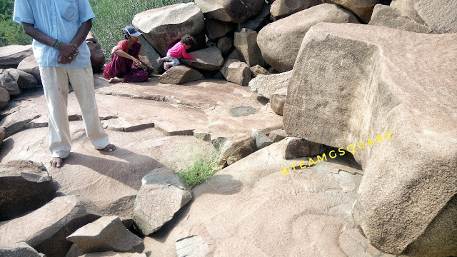 |
| Panchayat/ Court Hall |
Bull-Axe Wheel - The next intriguing carving here was that of a bull-axe wheel consisting of 5 bulls, which may have been the representation of a calendar that helped people prepare their lands just before the onset of monsoons. On closer observation, one can identify the axe carved in the shape of bulls legs and five such interlinked bulls forming a wheel in combination.
 |
| Bull Axe Wheel Carving |
Long Horned Sambar Deer - The next etching that caught our eyes was the beautiful depiction of a Long Horned Sambar Deer, which probably roamed here freely back then. It is disheartening that this animal is currently listed as vulnerable under the
IUCN Red List. Though the climb became a lot more difficult hereon due to the rocky terrain, the sight of such carvings kept us engaged.
 |
| Carving of Long Horned Sambar Deer |
Earliest Rock Musicians - The people of various settlements occupying this site made musical instruments out of the rocks found here. They made grooves of such kind on the rocks that when struck emitted different musical notes. Such musical instruments have also been found at other similar sites such as the
kettle's drum at Hirebenakal and the
drum at Mosalayyana Gudda at Hampi. Such musical rock instruments must have been an inspiration in the construction of many musical pillars that form a part of temples.
 |
| A Prehistoric Rock Music Instruments |
Other carvings sighted were that of a Barasingha, a few aroused men and erotic scenes.
 |
| Carvings of Barasingha, a Few Aroused Men and Erotic Scenes |
And Lo! Finally, we witnessed the most beautiful and unique of all carvings of this site. Of all the carvings here, this carving of a big three horned bull stands out, with each of its horn resembling a trident/trishula. Our guide named this carving as the
Nandikeshvara Kamasutra Panel, since it also included the depiction of a few erotic scenes. A peacock carving is also seen here along with the carving of an elephant.
 |
| Wow What a Scene ! |
 |
| Nandikeshvara Kamasutra Panel |
Carving of a Leader along with his Disciples.
 |
| Our Guide Sri Ramadasa and in the Background is a Carving of Leader along with his Disciples |
A rock with carvings of foot and hand impressions.
 |
| Carvings of Hand and Foot Impressions |
A Maduve (Marriage) yantra is carved here, which is still followed by the locals during their marriage ceremonies.
 |
| Maduve Yantra |
This could probably be the earliest reference to goddess
Lajja Gauri, the goddess of fertility. We were able to spot two such carvings here, one very elaborately carved with a lot of details and the other which was much simpler. These carvings are pretty much similar to the carvings found in
Usgalimal of Goa .
 |
| Carving of Lajja Gauri |
Hereon, our guide took us to the
Pitlappa temple where
people continue to worship even today, especially during the festival of Nagara Panchami. A small opening between the rocks forms this simple temple and is probably one of the earliest temple, devoid of any murti as of today. We are not sure whether any murti was installed here initially.
 |
| Pitlappa Temple, Sanganakallu |
Pre-historic Scribble Pad - This probably seems like one's to-do list or scribbling their ideas when struck to their minds so as to remember them later. There are a lot of carvings here that are simply out of this world. We spent maximum time here deciphering these carvings.
 |
| Prehistoric Scribble Pad, Sanganakallu |
 |
| Carving of a 6 Bull-Axe Wheel |
Carving of a pack of dogs.
 |
| Carving of a Pack of Dogs |
As the weather was too hot to continue further exploration, we gave up the plan of visiting the stone factory. We descended down and headed straight towards the ash mound here. This ash mound is one of the 4 ash mounds surviving today, though partially disturbed. To know more about it, do check our post on
Kudatini Ash Mound.
 |
| Kappagallu Ash Mounds |
We went further and explored the
Birappa Rock Shelter located close by the village of Kappagallu. Some of the paintings here can be dated to 9000 BC (Mesolithic period). Lastly, we spent sometime playing in the cold waters of river Tungabhadra flowing in a canal nearby the village of Kappagallu. What an amazing end it was to our journey! We later dropped Mr. Ramadasa to his house and thanked him for taking us around and explaining each and every rock in detail during this wonderful and informative tour.
 |
| Cave Paintings, Birappa Rock Shelter |
References:
1.
Wikipedia
2.
Megalithic
3.
Journeys Across Karnataka
Related:
1.
Chandravalli Cave Pre-historic Site
2.
Dolmen Circles of Doddamalathe
3.
Prehistoric Anthropomorphic Statues of Kumathi


