Pages

Wednesday, December 25, 2019

Ambajidurga/chintamani Fort

Caution: An entry to this hill is strictly restricted and a board instructing the same has been put up in order to prevent people venturing into this hill. Updated: As per the comments by Umesh Sir and Sudhakar, the restrictions have been removed and people can visit this place.

Good Morning Ambajidurga
          Ambajidurga, the second fort we were on a look out for, between Kaivara and Chintamani, seemed so near yet so far way. Ambajidurga is situated atop a hill adjacent to the very well known cave temple of kailashgiri and the temple authorities have banned the entry to this hill fort owing to the unfortunate incidents that have taken place here a few years ago. long back, during our visit to Kailashgiri, we had inquired about Ambajidurga and temple authorities  simply denied its presence and refused to give any information, only saying that Ambajidurga was another name given to Kailashgiri. When we told them that the fortification on the neighboring hill was clearly visible and insisted on details about the fort, they replied that there was no route to the hill and no one can go there. So we did not bother much about it, and thought we will explore this place when the time is right. This day was not too far from the day that we conquered Rehmangarh! We were much eager to conquer Ambajidurga. We reached the spot from where the hill base from where fortification was clearly visible. An old lady who stopped by told us about the route to the hill top and gave us directions. We were glad that a route to the hill top existed and went ahead following her directions. The hill was gigantic and we looked too small in comparison to its massive size.
First tier of the Fort
Lord Hanuman Temple and The Fort Wall
Broken Gateway Arch
   Overnight rains had made the path slippery, but that didn’t matter much to us as we were engrossed in the thought of reaching the fort. Our initial climb was a little tricky as after reaching a certain point, we realized we were heading in a wrong direction. We halted and to changed our course of climb and headed in the right direction. After a few minutes of trek, we reached the first tier of the fort on the first hill (or the lower hill) and rested here for a while. Later, a short walk lead us to the  top of the first hill which was an open plain land having a temple dedicated to Lord Hanuman and a few fort ruins. We were able to view the fortification on the upper hill but found no specific route. After investigating, we finally decided to make our own path and succeeded in our venture within no time.  We were at the fort entrance, and had a bird’s eye view of the surroundings including the now dwarfed fort of Rehmangarh.
Fort Entrance and Rehmangarh

Water Tank
Lord Shiva Temple
  The hill rises to about 4400 ft above mean sea level and was initially fortified by the local Palegars, which was then rebuilt by Tippu and finally fell into the hands of the British. There is a small temple atop the hill dedicated to Lord Shiva and a few ruined structures and water tanks. We were quite happy for having explored this fort too. We spent some time at the top and started to descend slowly and carefully down the hill. Our descent was a little tiring but calm, until we heard a person standing at the hill base shouting and signaling us to come down quickly. Initially, we thought of him to be a shepherd boy   calling out to his cattle, but later realized he was indeed waiting for us! Once we reached the base, he literally started shouting at us asking whose permission we had taken in order to go to the fort and my wife retaliated saying, we had inquired and only at the old lady’s suggestions, we decided to climb as she had not warned us about any restrictions. While he forced us to accompany him to the temple authorities, we insisted him on showing his identity card and if he did, we would surely go with him. Somewhere, we thought he was boasting about himself being a guard to the hill we had just explored. He argued saying there was a big board put up right at the entry point which strictly restricted any further entry. Truly, we were not aware of such a board. There was an exchange of words between him and us, and on demanding him to show where the board was put up, he took us a little away from where we started our trek and alas! There was the board! We told him that we had taken the path present much before this board and therefore had missed seeing it. We also questioned him about his absence during the time of our entry at the starting point. If he were to be a guard, he should have done his duty and cautioned us. We would have not ventured further at all. Finally a person associated with the Kailashgiri temple management who by chance had come to pick him, spoke to us and warned us in a rough tone saying that the place we had just ventured was really not safe and we shouldn’t have gone so far. On saying that we were not really aware of the board as it was put up in a wrong place and  since we had already made a safe return, there was no use of telling us now not to have ventured. There was an exchange of words again. It was slightly upsetting as this was the first time we had encountered such a rude behavior. Though our conversation ended sourly, we were quite happy that we had already explored the fort before they came and realized we would have missed so much, just in case destiny had taken us on the route towards that board! 
Lord Hanuman
 Mt Kailashgiri

Dwarfed Rehmangarh
Kissing the Clouds
     This was our dual-fort-adventure that ended with destiny being on our side. With both the regions being popular tourist spots, it’s quite hard to believe the fact that these hills are actually unsafe. We personally did not feel so, but who knows. Many places in Kolar district are considered unsafe, including the Antharagange hills. 

Friday, December 13, 2019

Dolmens of Talavadi

While ascending the Talavadi hill, we spotted a Dolmen-like structure on its neighboring hillock. I had marked in my mind to explore this hill after our descent. Once we were at the base of the hill, we went ahead to explore the Dolmen/megalithic site. A short climb led us to a flat portion of the hill and we walked straight to reach the Dolmen site. Yes!  It was a huge dolmen with a stone circle. But the sad part was that it remained slightly damaged, although most of its parts were in place.   The stones used for the construction of Dolmen were huge and nicely dressed, having an even surface. The size of the capstone of this Dolmen was roughly around 6 feet by 6 feet in length and breadth with its depth/height varying between 4 to 10 inches.
Disturbed Dolmen (No.1)
There was a natural water pond nearby and while exploring this area, we found another dolmen with a stone circle. But this had been completely destroyed with just one of its stone slabs standing, while the rest were missing. Probably the stones were removed from here by miscreants. This stone Dolmen is very similar to the first Dolmen in its dimensions, going by the sizes of the stone circle and stone slab. After finding this, we became more curious and started to investigate this small hillock for more such structures. We went on to find another stone circle that lay completely disturbed. While walking around the hill, two fully intact Dolmens on another neighboring hill caught our attention and we were intrigued to explore that too!!!
Remains of Dolmen With Stone Circle (No.2)

  We tried to figure out the way to this neighboring hill which seemed nearby, but since no direct route was present, we decided to circumvent and reach this hill. This walk was much longer than we thought as we had to cross numerous small hillocks on the way. On one such hillock, we spotted a Dolmen without a stone circle. The Dolmen was in a much better shape though a bit disturbed. Except for its front stone slab, all the others were laid in situ. Probably, this never had a front slab or it has gone missing. An anthill present inside the Dolmen obstructed our view and we couldn’t see much. 
Solitary Dolmen on Hillock (No.3)
Moving on from here and after walking for a good 15 minutes, we reached a check dam. After crossing the check dam, we entered into agricultural lands walking across which we found a bigger Dolmen that had been excavated by the locals in the greed for treasure; the site however would have carried plenty of bones and pieces of pottery. Here in this land, we could spot a few dolmens spread across, but the land comprised of standing crops which prevented us from venturing inside for inspection. Finally, after crossing all the farmlands, we found a small foot route to the hillock on which we spotted the two intact dolmens. 
Excavated Dolmen ( No.4) 
Dolmen Along With Standing Crop (No.5)
Intact Dolmen ( No. 6 &7)
Finally, after exploring the area, we reached the spot that had intact dolmen giving us a fair idea of the Dolmens once stood here. One of them had a porthole on the eastern stone slab and only one we had come across here with a porthole. These two were also so same size we had come across in this area. Though nothing remained inside these dolmens, it was good to see them intact. From here we took another route where we came across the place that looked like an ancient quarry site. Little further we found the fort wall probably the first tier of the Talavadi Fort. So we completed the circumventing the hill on which we spotted the dolmen. Thus completing adventurous trek and exploration.
Talavadi Hill in the Background
Dolmen No.6 
Broken Port Holed Slab 
Our efforts to find any documentation related to this place went in vain. By looking at the style and sizes of the stones, the Dolmens can be safely assigned to a period between 1000 BCE – 300 BCE. There are two articles in the KarnatakaItihasa Academy that mention the presence of megalithic sites around Kootgal Hill, although they fail to mention the existence of these dolmens. We only hope that the remnants survive the test of time and human greed. Megalithic structures are mysterious and need in-depth study in order to understand their purpose, rather than superficially relating them to burial practices. Of late, a lot of research is being carried out in this direction in order to gain more clarity.
Related Posts:

Thursday, November 28, 2019

Talavadi Fort, Ramanagar - A forgotten fort


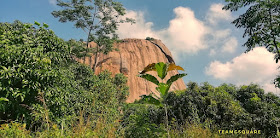
Talavadi is a small nondescript village off Ramanagara – Magadi road. Though not much history about this place is documented, it has in store many untold stories. Last Sunday, we got a chance to trek Kootgal Betta we spotted this fort and decided to trek next week. We planned and reached Talavadi quite early in the morning to start our trek.  I was accompanied by my son Adhi and my friend Shashi Kiran. We had our breakfast in Ramanagara and reached the deviation off the Ramanagara – Magadi road. Hereon, we began our off road drive to reach the base of this hill.  We had to make a few enquiries with the locals about the directions to reach the hill base and the trek route thereon. An elderly person informed us that it would be difficult to climb this hill as the route had been engulfed by grass and other thorny vegetation, and gave us the directions vaguely. We thanked him and decided to move ahead towards the hill base. 
Challenging Climb Near Bengaluru
Talavadi Hill Fort
We had to park our vehicle at a point from where there was no motor-able road, and had to walk to until the start point of the trek. At the first look, the hill seemed small giving us a thought that it wouldn’t be much of a challenge to scale the hill. We started our search for the trek route and reached a small temple dedicated to Udbhava Anjaneya Swamy. The guardian Lord reminded us to search around for the presence of any fort or its ruins.  After taking the blessings of the Lord, we decided to move ahead and actually had to almost circumvent the hill in search of a proper route to climb. After walking for almost 15 minutes, we reached a big water pond. Just by the side of the pond, we sighted a path which seemed trek-able and hence decided to ascend from here. 
Water Pond and The Fort
Sri Udbhava Anjaneya Swamy
 The initial climb was quite easy and straight forward, and we reached a tier of the fort wall.  Here we met two boys from Bengaluru who were also there to explore the hill. As we struck a conversation with the boys, I realized that they too were in search of the right path to continue their climb. I volunteered to search the environs for any path that could be walk-able.  Meanwhile I requested the others to rest at a place in shade and went in search of the route. After exploring the surroundings for some time, I zeroed in on the most probable route that could be taken to reach the top. I called the others to join me, along with Shashi and Adhi. Shashi took charge from here leading the way. Seeing the route that was to be taken hereon, the two boys gave up the trek and left the place without informing us! The vegetation was dense with tall grass and thorny shrubs.
Wade Thru the Grass and Thorny Shrubs
The Rock Cut Steps
Kootgal Betta
We continued to crawl under the grass and thorny shrubs and finally reached a point from where we were almost sure about the path further. Shashi did a wonderful job in finding the path and we reached a spot which had big boulders on either side. We sighted much fortification on the left boulder and so decided to explore it. The boulder was very steep with rock cut steps to aid the climb and passing these 15 odd steps was one hell of an experience! We reached the top of the hill which housed a ruined mandapa kind of a structure along with a fresh water pond. The fresh water pond was filled with many beautiful white lilies.  We spent some time enjoying the sight of the water pond and its surroundings. 
Fresh Water Pond
Flying High
Mandapa and Nadadwaja
White Water Lilies
As per an inscription found near Ramanagara (EC Vol 9 Ch 16) dated 1351 CE, Talavadi was ruled by a local Palegara named Bomanna, who was a feudal king under the rule of Bukkanna Vodeyar of Vijayanagara Kingdom. Later Sri Kempe Gowda captured and strengthened this fort, which mostly served as a military outpost during his rule.  Though much of the fortification has been damaged, its remnants give a good picture of what a grand fort it was once. The formation rocks are such that they served as natural defense from the three sides and the fort was only accessible from one side. At a few places, we were able to spot horse shoe marks which are a common sight across forts built by the Kempe Gowda clan. 
Horse Shoe Marks
Cliff Hanging
The descent posed us a challenge where we had to cross the 15 steep steps and we had to literally cliff hang for some time.  The descent across the grass and thorny path too was a bit challenging as we had to overstep and pass through them. Once we were out of this, the descent was easy. As we continued our descent, we spotted something really interesting on the neighbouring hill and decided to check them out on reaching the hill base.
The Dare Devil
Full View of Talavadi Fort
Hunt Begins
 To be continued. ….
  
Related Posts:

Tuesday, November 19, 2019

Hoysala: Mallikarjuna Temple, Hirenallur, Chikmagalur

  While zipping through country roads to reach Amrithapura, which is home to one of the most beautiful Hoysala temples, we stumbled upon a milestone having the familiar name of Hirenallur. On checking our travel diary, we realized this place too housed a Hoysala temple dedicated to Lord Mallikarjuna. As we had more than one option now, we were in a dilemma and as time was ticking, we had to decide quickly.  We made a quick inquiry about the temple and decided to proceed as we heard it was a ‘not to miss’ temple. Not wasting much time, we headed towards this temple and in about ten minutes time reached this magnificent temple.
Hoysala Mallikarjuna Temple Hirenallur Tarikere Chikmagalur
Mallikarjuna Temple 
8th Century Ganga inscription 
   Hirenallur is a small village of Kadur Taluka of Chikmagalur district. The Mallikarjuna temple situated here is a very beautiful Hoysala temple lesser known to the world. There is very little information about this temple on the Internet and print media. The temple is believed to have been built initially by the Gangas during the 8th century according to an inscription recently found here. Later the Hoysala king Ballala II renovated this temple and must have added the two cells to the main cell during the end of the 12th century.
Very Beautifully Decorated Shiva Linga 
Heavily Decked Central Ceiling 
Tandaveshwara on Central Ceiling 
Central Ceiling Hoysala
Complicated Craving on the Ceiling 

Lord Vishnu Ananthasayana
Lord Ananthasayana 
Lord Shiva and Parvathi
Uma Maheshwara 
   The temple is a trikuta with Shiva Linga, Keshava, and Surya Deva adorning the cells. The central ceiling is a masterpiece with complicated carvings on it and overshadows the beauty of this temple. There are sculptures of Ganapathi and Sapthamatrikas in the sabha mandapa of the temple as usual. The three Shikaras of this temple are heavily decked with images of the various gods and goddesses on them. This temple has been renovated by a few keen locals with the help of Sri Dharmasthala Trust under the guidance of Dr.Veerendra Hedge.
Lord Ugra Narashima 
Shikara and Outer Wall 
Carvings on the Shikara 
Veeragallu 
    There is a big and beautiful garden around the temple.  Another small temple adjacent to this temple is dedicated to Mailara Linga, housing two beautiful idols of Mailaras. On our way back, another small beautiful temple amidst a farm caught our eye.  This one too was dedicated to Lord Shiva in the form of a Linga. 
Mailara Linga 
Shiva Temple in the Farm